
Impact Based Forecasting (IBF)
Training For Anticipatory Action
The Southern African Development Community (SADC) member states are tasked to respond to differing disaster risk scenarios, ranging from snowstorms, to heat waves to flood, cyclone and drought risk. In supporting the SADC Region, IFRC, FAO and WFP are jointly implementing an ECHO-funded project titled Building capacity in Southern Africa to enable effective disaster risk management through regional systems for inter-agency anticipatory action using a multi-hazard, multi-sectoral approach.
Impact-Based Forecasting (IBF) has been identified as a transformative approach to weather forecasting that focuses on predicting the potential impacts of weather events rather than just the weather conditions themselves. Instead of simply forecasting what the weather will be (e.g., heavy rain, strong winds), IBF aims to forecast what the weather will do (e.g., flooding, infrastructure damage, disruptions to daily life). By integrating hazard data with information about exposure and vulnerability of populations, assets, and infrastructure, IBF provides actionable insights that enable proactive measures to mitigate the impacts of natural hazards.

IBF training participants posing for a group photo
The Training on Impact-Based Forecasting (IBF) for Anticipatory Action was organized by the Regional Anticipatory Action Working Group (RAAWG) in collaboration with the South African Weather Service (SAWS) and Red Cross Red Crescent Climate Centre. It was from 13th to 15th of May 2025, and was attended by representatives from Meteorological Services, disaster managers (from government departments and Red Cross) and media personnel. Representatives were from five countries, namely Zimbabwe, Zambia, Mozambique, Lesotho and South Africa.
On the first day of the workshop, SAWS presented on an overview of Impact-Based Forecasting (IBF) where they led in discussions on impact tables.

Participants during a discussion session
Impact tables allow forecasters and disaster managers to associate the most likely impact level with an area with the likelihood of impact to occur. The impact level then determines where on the risk matrix an expected event lies. Impact tables are based on disaster management knowledge and experience.
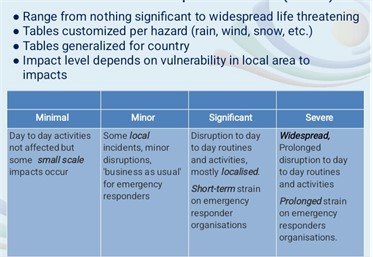
Sample Impact Table
During the second day of the workshop, there was a closer look at the Risk Matrix and Communication of Messages. To produce a risk matrix, forecasters identify the likelihood of an expected hazard in tandem to its potential impact. A risk matrix helps to determine the level of a warning depending on the likelihood and impact of the expected hazard.
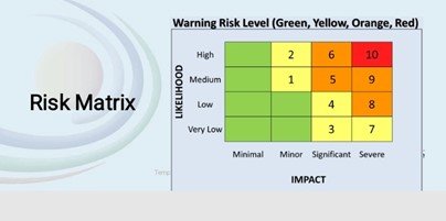
Risk Matrix
In Zimbabwe, dissemination of early warning information is done through various media in collaboration with the Department of Civil Protection (DCP). The media include community radios, WhatsApp platforms, SMS, print and electronic media among others.

Standing: Mr Masvora Director at the Department of Communications, Ministry of local Government-Zimbabwe explaining how disaster information is cascaded to the last mile
The training required countries to give updates on the IBF progress. For Zimbabwe, it was highlighted that progress had been made in the implementation of IBF through coordination by the DCP. This arrangement has enabled the Department to leverage on already existing structures in the rollout of the IBF. Simulation exercises have also been done which have assisted in continued improvements in the forecasts. The Department has so far produced rainfall, thunderstorm, strong winds, temperature, and ground frost impact tables. However, rainfall tables still need to be improved. Each of these tables outlines threshold, severity and possible impacts of a hazard to targeted areas. These were developed in collaboration with our stakeholders through the Civil Protection structures.

In front: Linos Ncube presenting on IBF progress in Zimbabwe
On the third day, a disaster simulation exercise was held in Katlehong community in Ekurhuleni municipality. South African Weather Service issued a disaster warning of heavy rainfall and tornado that was expected in the community around 1400hrs on the 15th of May 2025. Community members were told to evacuate to a safe place which was the community hall.

Volunteers on their way to distribute evacuation fliers to the community
The movement and response of community members was monitored using a drone. Some of the community members responded well to the call while others took longer to arrive at the evacuation centre. Upon arrival members of the community were informed that it was a simulation and there was no need to panic.

Drone pilot monitoring activity in the community
An in-depth discussion was held on how disaster information was relayed and their expectations in future. Some of the key points highlighted were use of local language in information dissemination, using trusted communication channels like local leadership, through community WhatsApp groups and broadcasting information through local radio station.
Conclusion
Zimbabwe is one of the countries that has embraced the Multi-Hazard Early Warning for All Initiative, aiming not to leave any place and no one behind. The country is part to the September 2022 Maputo Declaration on Commitment by SADC Member States to bridge the time gap between Early Warning and Early Action. The Early Warnings for All (EW4All) initiative aligns with the country’s developmental strategy (NDS1). The NDS1 prioritizes increasing investment in Disaster Risk Management Systems including early warning systems and contingency planning to enhance the country’s preparedness in the face of hazards. Impact based forecasting is beneficial to the country and efforts are ongoing in developing the Early warnings For All Road map to ensure its sustainability.
Meteorological Services Department, 2025